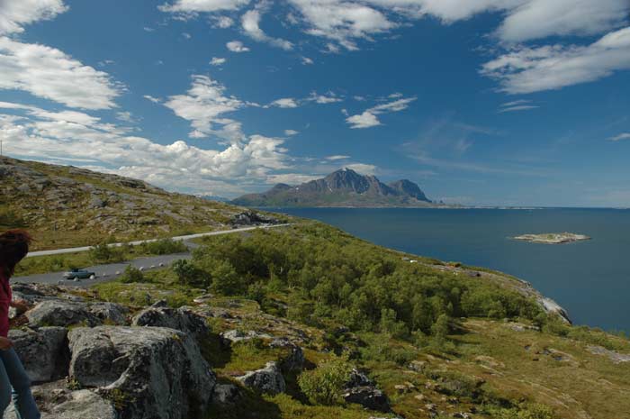
The great weather we had last night while watching the midnight sun carries over to today. It is wonderful - sunny and very warm. We are ready to go. We are up earlier this morning and leave around 9:30 AM. We carry along on route 17 and this stretch is very pretty with wonderful views of the sea dotted with the many mountainous islands.
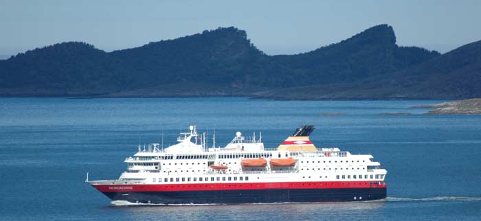
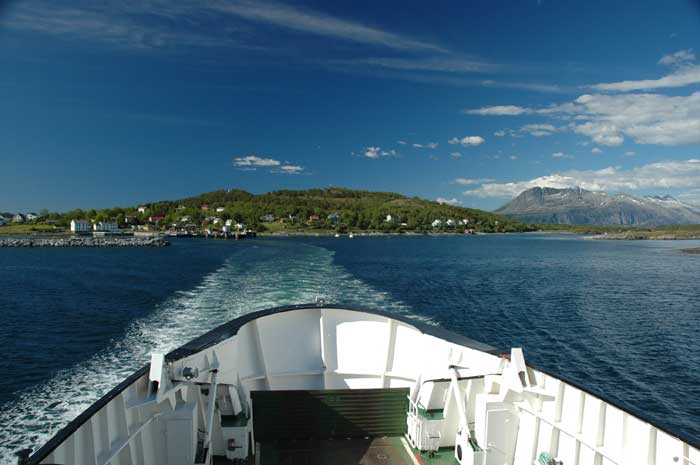
Soon after we leave the campsite we come upon a high hill where we stop for a view over the sea. We are fortunate to notice that one of the Hurtigruten ships is passing by and it is nice to see at a distance the boat that took us all the way to the top of Norway. After snapping a few pictures, we are on our way.
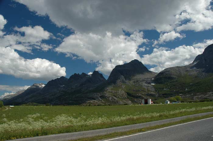
We make our way around the Sjonafjord, which requires a long drive around this arm of the ocean that cuts into the land. As we approach Nesna, we come to the highest point on this road at Sjonfjell at 350 meters above sea level. We have wonderful views of the hat shaped Lovund and Træna islands just off the shore. We are separated by only narrow channels.
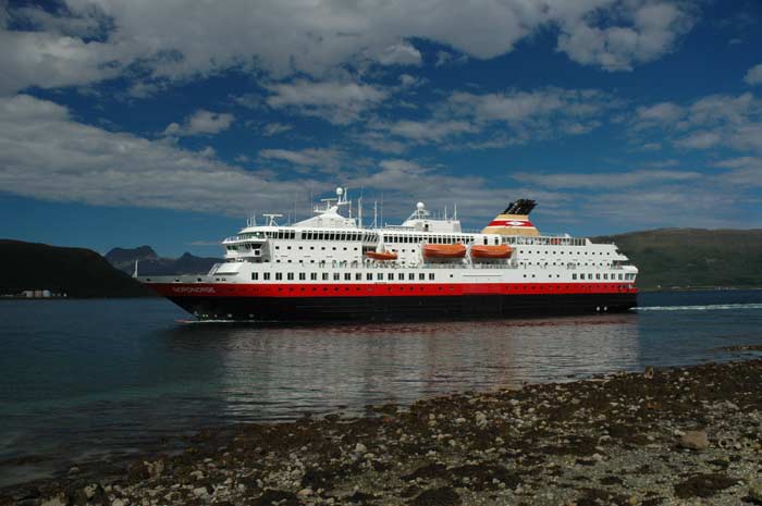
But these stops for photos and the views costs us - we miss the ferry that we hoped to catch from Nesna by one minute. Well, we have no option but to hang around here. It turns out there is another Hurtigruten ship in port and it is just getting ready for departure. It finishes loading it's cargo and then pulls away from the pier and makes its way south.
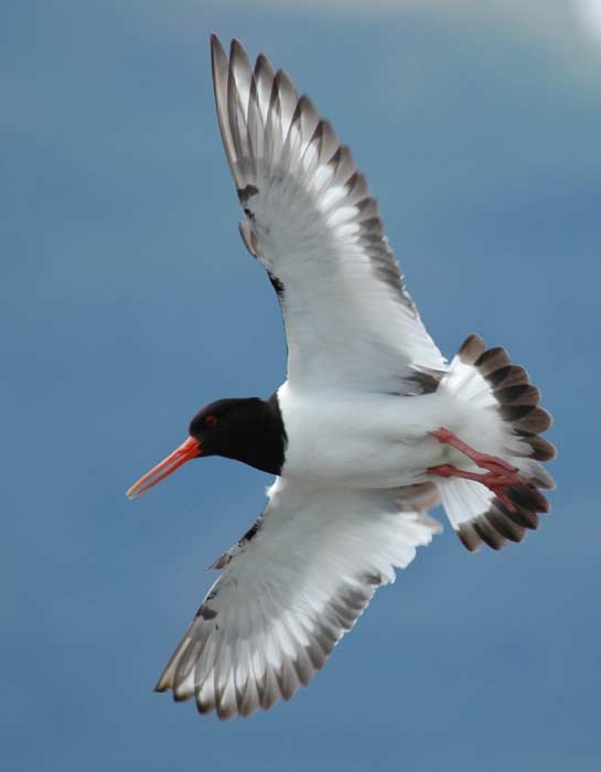
We also spend some time watching the many birds flying around here. We try to get some photos of them flying in mid-air, but they are fast. Soon it is time to head back to our car to catch the ferry that is just pulling in. We pay our fare and then drive aboard just at noon.
The ferry takes us only about fifteen minutes to cross the Ranafjord to Låvong on the other side. We carry on from here. We make a brief stop to by some groceries. Soon we are crossing the Leirfjord on the 1,100 meter Helgeland Bridge.
And then comes the sight of the Seven Sisters - a series of seven peaks, the highest of which is 1,072 meters, on top of a long mountain range that juts up from the long island. The peaks were formed when glaciers carved out large cirques between them. Unfortunately it is hard to get a good photo - the sun is coming from behind the mountains.
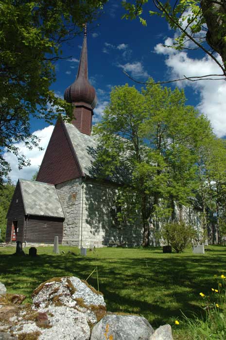
Our next stop is at Alstahaug, where the famous Norwegian poet-parson Peter Dass lived and ruled as a minor "king" in one of Norway's richest parishes. The old church and vicarage have been turned into museums. We decide to stop and look around. But first a quick lunch before we join the next English tour.
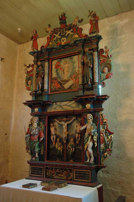
The original church, the rectory, was built in the 1100s and the nave was added in 1865. It was restored in 1971. We wander around the interior and learn more about the colorful life of Peter Dass. While in this parish, he collected the tithe in the form of fish which he would sell in Bergen. He is described as a very fierce man, but at times compassionate and caring.
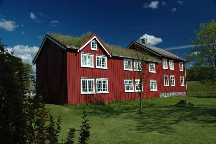
We then went on to the vicarage, built in 1650, and wandered around the museum. An interesting place, but soon it is time to head on.
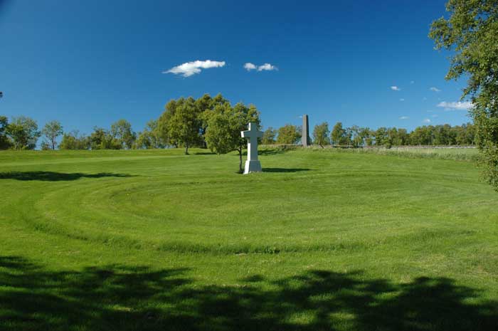
A short distance down the road, we come to the Russian cemetery where all the POWs that died were buried. We were told that during the height of the cold war, all the remains of the Russian POWs that died in various parts of Northern Norway were brought here so that Russian spies did not have a reason to travel all over the country paying respects to their countrymen. There are over 8,000 people buried here, most of which were never identified. Right next door is the memorial to the 2,587 Russians, Germans, Poles and Norwegian prisoners killed when Allied planes sunk the "Rigel" off Tjøtta in 1945. 1,011 of the killed are now buried here. It is a moving place.
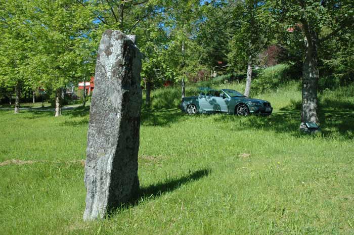
From here we drive the short distance to Tjøtta, where we will catch our next ferry. But we have about an hour to wait until our ferry arrives, so we decide to see some of the sights around the town. The town has numerous ancient monuments dotted here and there. We are able to find a number of the monoliths, including the Griddle, the Rolling Pin and the Dough (not kidding you - those are their names).
Our ferry to Forvik takes us about an hour. This ferry has been a bit delayed, so when we get to the other side, we need to rush to make sure that we can catch the next ferry that leaves from Anndalsvågen. We are driving behind a truck that also clearly does not want to miss this ferry - it is the last ferry of the day. We arrive there with a few minutes to spare and drive onto the ferry.
This is a short ride across the Velfjord to Horn. From Horn we make our way down the coast towards Brønnøysund. But we do not spend any time in this relatively large and sprawling town. We pass through on our way to Torghatten. We have to make our way along a stretch of road with low speed limits and lots of speed bumps. It takes some time.
But soon we arrive at the base of this unique mountain. It is known as the mountain with a hole and it is linked to folklore and fairytales. The mountain is 260 meters high and the hole is located at 112 meters above sea level. People used to say that a fully rigged yacht could sail through the hole and they were right. The hole is 37 meters high and 27 meters wide and 160 meters long. the holes was formed when the land was lower and frost and the sea eroded the granite.
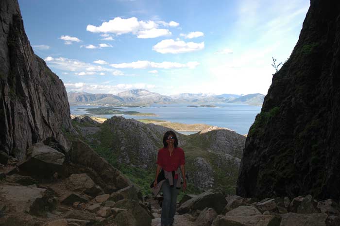
We began the walk up the side of the slope to the hole. The trail is well prepared, made for the thousands of tourists that visit this place each year. It is a fascinating natural phenomenon. We are standing at one end of the hole and looking through this massive tunnel to the blue sky and sea at the other end.
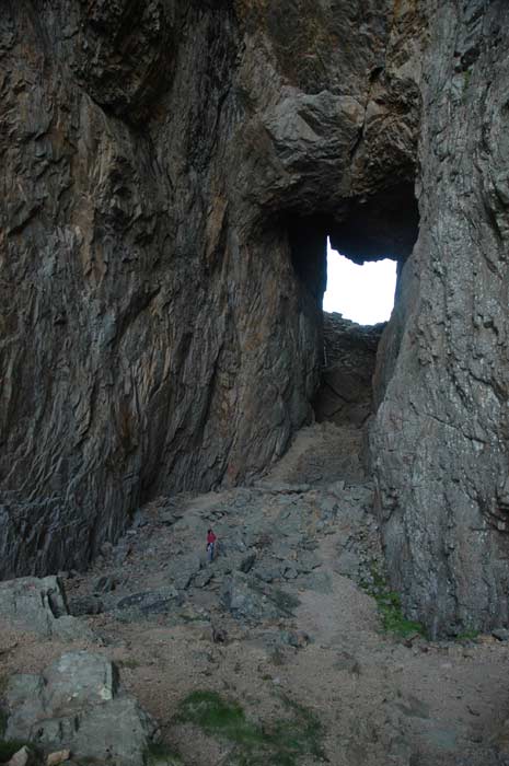
We then begin the walk through the hole - the route is not even - we have to climb up and down some stairs and rocks. It is a huge cavern.
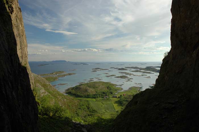
We soon make it to the other side and we have a great view of the sea and the scattered low-lying islands. It is a beautiful sight. We hang out there for a while and then begin our balk back through the tunnel.
From the other side of the tunnel, we make our way back down the trail to our car and drive on. We need to backtrack to Brønnøysund over the bridge from the island of Torget to the mainland. We make a brief stop to buy some groceries and then head on. Even though it is almost 8 PM, we decide to cover some ground this evening.
We will now leave route 17 and carry on east on route 76, known as the Tosenveien road, as we make our way to the E6. We shall see how far we can drive and then stop for the night. It certainly is a beautiful road that winds it's ay through majestic scenery. After about half an hour, we have a near miss. Jacqui is driving, and Lars all of a sudden spots some large brown objects approaching the road up a steep embankment. Lars shouts "horse, horse". Jacqui is like, so what, we see horses all the time. Then as we move forward, the two brown objects make their way onto the road and we notice that they are moose. Thank God they must have sensed us, because all of a sudden they turned and bolted.
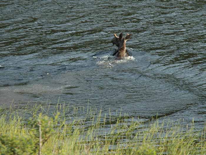
We came to a screeching halt. If they had not bolted, we would have hit them and they would have made a frightful mess of our car, if not us as they came hurtling over the windshield onto our laps (the top was down). We quickly backed up to see if we could get a sight of them. Upon seeing us, they jumped into a lake that barred their way and swam away to the shore on the other side. What a magnificent sight - and we were so happy that we did not injure or kill them.
We carry on and we are really wondering when we will find a campsite. We slow down at a few possible spots, but they did not look very attractive. Then we came up a campsite at the end of the Tosen fjord. The place seemed deserted, but when we knocked on the door of the owners house, they told us that they had a cabin available. The price was good and the cabin was very nice, so we took it. It was already 9:30 PM. Another late dinner.
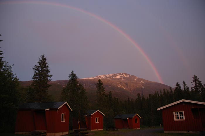
Well, we quickly cook up dinner and then get ready to have a shower. A few clouds have come in and as we go to the shower building, we notice that a light drizzle has begun to fall. And this results in a beautiful natural show - we get bright double rainbows that arch from one edge of the horizon to the other. They are the most fantastic set of rainbows that we have seen. And the amazing thing is that they hang in the sky for over an hour.
We would go out every once in a while to check out how the rainbows were doing. They just kept on hanging in the sky. It was like they were a permanent fixture. Also, remember, we are watching these rainbows just before midnight - the amazing things the midnight sun can do. But soon it was time to retire for the night.