Today we will try to cover as much ground as possible. We need to get down to Koppang by tomorrow for Lars' cousin's birthday celebration. Also, the weather is not the best, so we will not make as many stops. We leave at around 10:30 AM and head east towards E6, where we turn south. Along the way we leave Nordland and enter Nord-Trøndelag.
Our first stop is at Fiskemfossen, where they have a large salmon center built around the fish ladders built into the dam. We decide not to enter, especially as they are charging admission. We do not have much time to spend there anyway. We carry on south on this main artery - it has what seems like to us a huge amount of traffic. We have been used to traveling on the roads in northern Norway, where you see other cars only occasionally. Now, there are cars everywhere.
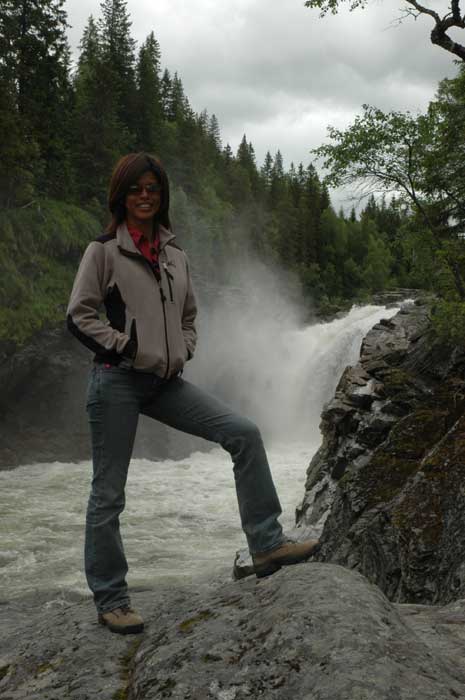
At around 1:30 PM we stop for a quick picnic lunch at a rest stop overlooking a valley. After wiping away the water from the picnic table, we are able to enjoy the spot. After our lunch, we come upon Formofossen, which is a beautiful waterfall that drops 34 meters through a narrow canyon in the Sanddøla River. We pull off the E6 and walk the short distance to the falls.
From these falls we make our way further south to Snåsa, where we leave E6 and take the smaller and slower route 763 around the long lake. We make a brief stop in Snåsa to take a look at the medieval church and cemetery. It is a beautiful drive around the lake.
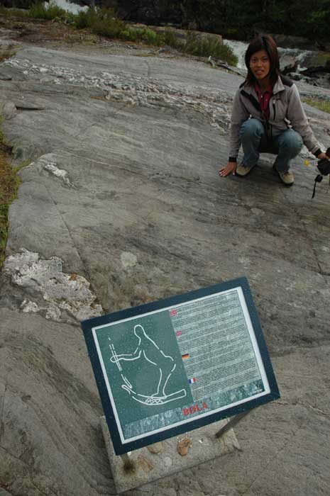
While on our drive around the lake, we stop at Bølareinen which has 6,000 year old rock carvings. There are not many of the carvings, but they are very interesting to see, in part as they are completely exposed and open for viewing. In some ways, we are surprised they do not have more protection. Well, we park our car and walk the shot distance down to the carvings.
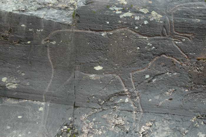
There are only a limited number of carvings, but they are artfully done and we are able to get a close look at them. The most famous is the carving of a reindeer drawn to scale with naturalist artistry. We spent some time examining it.
There are also a number of other carvings, and they have not painted them in, so we have to look carefully to identify them. It is amazing that these have been discovered. After spending some time checking them out, we make our way back to the car and carry on around the lake.
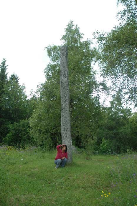
We rejoin E6 at around Steinkjer. But first we take a slight detour to check out the two big burial mounds on Helge Farm at Byafossen. There are also three monoliths and a ring with eight stones. They are hard to find as they are not well marked.
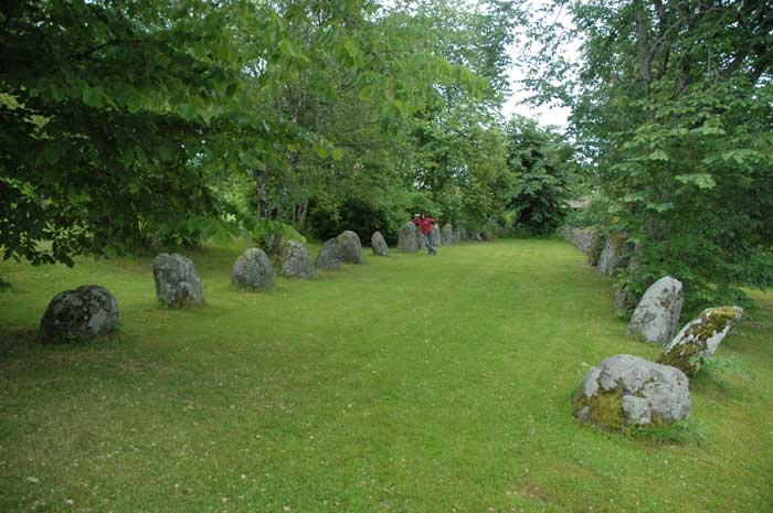
Then it is onto the relatively large town of Steinkjer, where we try to find the area of Tingvoll. The road system is undergoing change, so we have some troubles following the map. But in the end, we find one of Norway's largest stone rings - 35 meters long with 38 erected stones. This early Iron Age burial mound sits on the grounds of a hotel. It has started to rain, so we take a quick look and then make our way through town back onto the E6.
As we have come so far, we decide to take the detour to Stiklestad. This is one of the most important places in Norwegian history and we have heard about the Battle of Stiklestad at so many other tourist sites that we have visited that we just had to come here. We turn off E6 at Verdal, where many of the huge offshore oil drilling platforms are built.
Stiklestad is famous as the place where King Olav Haraldsson's army in 1030 met in battle with it's enemies. King Olav died in the battle and his death formed the foundation for his status as a saint - St. Olav. St. Olav was trying to introduce Christianity into Norway and he was returning to re-take his Kingdom after being forced to flee two years earlier. Following his death, the transition from paganism to Christianity began in earnest. The cult of St. Olav spread throughout the Nordic countries and even other countries in the West.
In addition to the cultural center and the large open air theater where the St. Olav's drama is played out each year, there is the medieval Stiklestad church built in 1180. This supposedly marks the spot where St. Olav died in battle. We first go and check out the church.
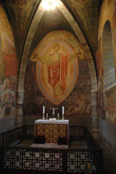
It is actually closed, but a priest is talking to a couple that plans on getting married. We walk around while he is discussing their plans. Afterwards, we strike up a conversation with him and he is kind enough to tell us some things about the church. The most amazing feature about the church are the striking Alf Rolfsen frescoes in the chancel that depict scenes from the battle and Olav's "resurrection" as a sanctified King.
Then we head over to the cultural center. We do not check out the museum, but we walk around the grounds and check out the large open air theater. They are getting it all ready for the 50th anniversary performance in July. From here we check out some of the old buildings and then make our way back to our car.
It is almost 7 PM and we just carry on from here. We want to cover some ground, while also looking for a place to stay for the night. We drive on south past Trondheim, then at Støren we turn off onto route 30. We start to check out some campsites here, but they seem far off the road, so we decide to carry on. This may have been a bit of a mistake. It has started to rain, so we really want to look for a hut - we do not really want to camp with our tent in the rain. So we begin the drive along route 30 towards Røros. It is a beautiful drive, but in the overcast rainy weather and low light, it is hard to enjoy it.
We come across a few campsites with huts - just one problem, they are all fully booked. It appears that this is a very popular fishing river and it is Friday, so all the fishermen are out in force. And we can see them out there, even tough it is already 10 PM and raining and cold.
We have to drive all the way to Røros. But we have no luck there. In the end, we find out there is some festival going on, so everything is full. We check out all three campsites and some hotels - they are all full. It is now midnight. In desperation, we drive out of Røros and make our way south. We come upon a campsite at Os, and are pleased to discover that they do have a hut left. We grab it - any port in a storm. In the end, it turns out to be a very nice hut and campsite. Rather than cook a hot dinner so late, we decide to have a light, cold dinner and then it is straight off to bed.