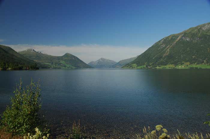
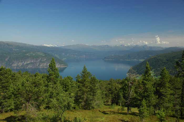
After our usual breakfast and packing up, we go and get the car filled with petrol and top up the air pressure in the tires. Then it is time to head off. Today we will do some of the most scenic driving of our entire trip in Norway - it turns out to be a great drive. Rather than take the faster E39 road on the northern edge, we decide to take the scenic route around the southern edge of the lake. This road is about wide enough for one and half cars and snakes along the edge of the lake. It is a fun drive with great scenery. We are also driving in the sun, which keeps us warm in the cool morning air as we drive with the top down.
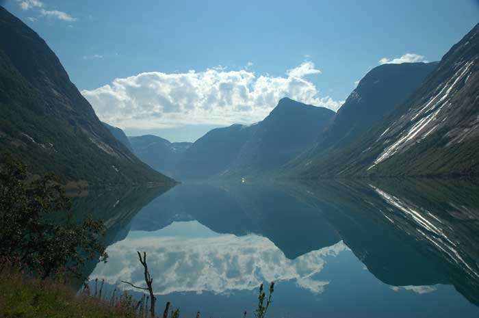
At the eastern end of the lake, we decide to take a detour turning south towards Fjærland and the glacier museum. And along the way we see some of the most stunning scenery. It is just awesome. The views down along the thin lake with the steep mountains on each side rising up to the clear blue skies above is spectacular. We drive along the edge of the lake, passing through a few tunnels and making frequent stops to enjoy the view. When we get to the end of the lake, we look back and are rewarded with a fantastic view. It really is a superb spot.
From here, we drive up towards the pass that will take us to the valley on the other side of the mountains. Just as we are about to enter the tunnel, we get another great view of the lake below us. We then pass through the 6.3 km tunnel and emerge on the other side with another wonderful, but different, view to Fjærland.
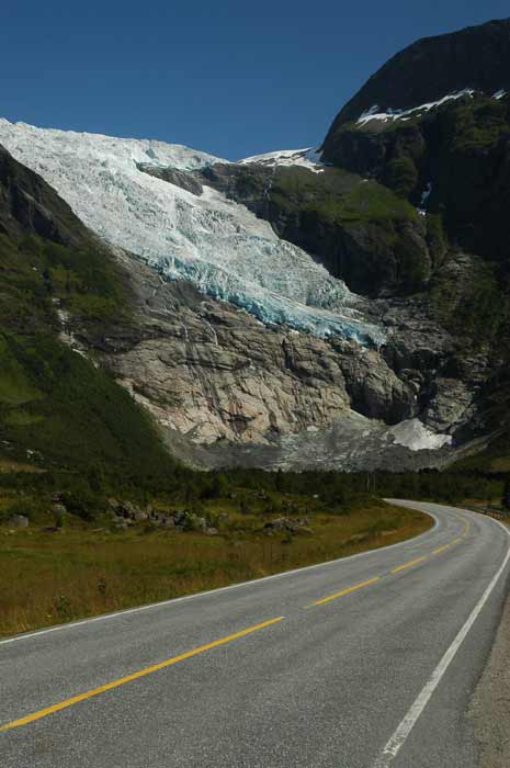
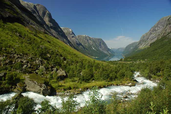
The huge Jostedalsbreen glacier is to our left, pouring over the edge of the top of the mountains. We are driving towards the Fjærlandsfjord, which drives like a wedge through the mighty mountains on each side. Our goal is the Norsk BreMuseum (or Glacier Museum). We drive up to the museum and upon our arrival we realise that we have already been here. We visited the museum during our honeymoon. Oh, well - what to do. We decide to skip seeing the museum and head back. But we are glad that we did the detour - we got to see some really magnificent scenery and we get to see it again on our drive back.
And we enjoy it as much on the way back as on the way in. It is a very beautiful spot in Norway. Once back at the turnoff, we re-join E39 and carry on north through Våtedalen between precipitous mountain walls to Breim parish. At Byrkjedal, we turn off onto route 60. Soon we come to the hairpin turns that take us to Utvikfjell, 630 meters above the fjord. At the Karistova Inn, we stop to enjoy the fantastic views of Nordfjord. Then down we go on the curving road to reach the Nordfjord and begin a long circuitous drive along it's shores.
After going all the way around the fjord's eastern reach, we reach Stryn, where we turn east onto route 15. But we do not drive on this new, modern road for long. We turn off and join the old road that used to be the only way through this area. Route 258 is the old Gamle Strynefjellvegen. It is one of the national tourist roads and is about 110 years old. For many years, this was the only connection between east and west Norway. It has been very well restored, even to the point of using the old guard stones along the steep edges.
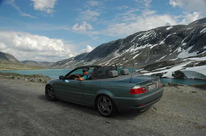
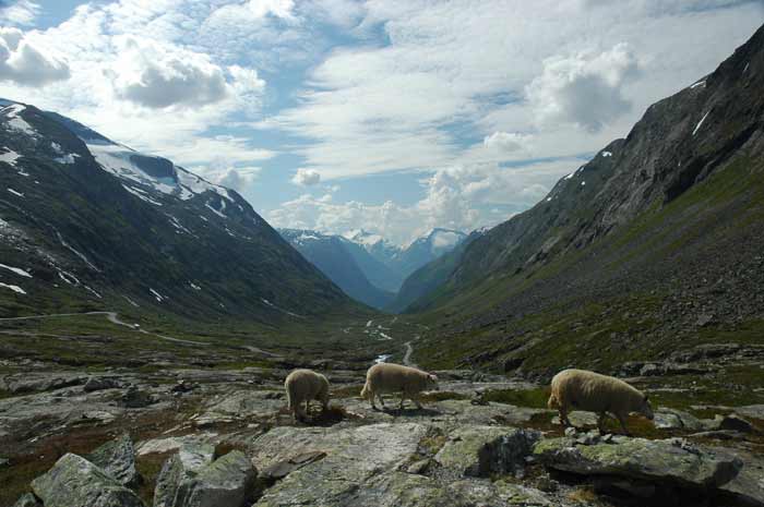
Originally built for the days of horse and carriage when it was opened in 1895, it has also served motorists well. While we will be going a bit out of our way, it is well worth it. We climb up the many bends to reach Videseter, with amazing views across the valley to the tall mountains in the distance. There are glaciers and lakes. It is a rugged area, rocky with spots of snow here and there still left over from winter. Half way, the paved road gives way to a dirt gravel road. At any decent speed, the road takes careful handling. We can feel the car slide on the corners. But we make it safely, the biggest concern being oncoming cars around the many blind corners.

At Grotli, we re-join route 15 and turn back west. We need to head back a short distance in order to reach our turn off to our next destination - Geiranger Fjord. The drive from here to Geiranger continues to a beautiful one. While the road is of a better quality, it still winds it's way amongst the rugged hills and terrain of this area. We pass lakes and waterfalls. At Lake Djupvatn we reach the summit of the Geiranger road, and slowly begin our descent towards Geiranger. At first, however, you barely notice that you are heading down - that comes later.
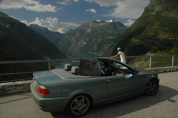
Soon we are at the top of the mountain overlooking the fjord - what a sight. It is one of the most beautiful fjord's in Norway. We have been here a few times. Most recently we visited when we were heading north on the Narvik, the Hurtigruten, in June. Longer ago, we visited when we were on our honeymoon after getting married in Lom. That time, we ended sleeping over night in our car on the first night of our honeymoon in this exact car park as all the hotels and campsites were full. There was nothing to be found, so we compromised by sleeping in the place with the best view in town - this car park. What a night.
Anyway, back to the present. Once we have taken in the beautiful view, we begin the steep descent down to the valley floor on the twisting and turning road. The road was first opened in 1885 and some of the original construction is still visible. One of the highlights is where the road ties a know around itself at Ørjaseter. Today the knot - Knuten - is preserved as an example of 19th century highway construction. We see the sign pointing to the exit for the Knuten, and it is a pretty cool thing. We drive over a small bridge, curve around and drive back under the bridge's arch. Amazing.
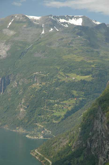
We carry on down the windy road and soon end up at the base of the fjord at the small village of Geiranger - now a huge tourist attraction. We decide not to stop - we are not really interested in the shopping and it is very crowded. We now begin the climb up Ørneveien - or Eagles Road. It is another fantastic winding road up the steep mountain side.
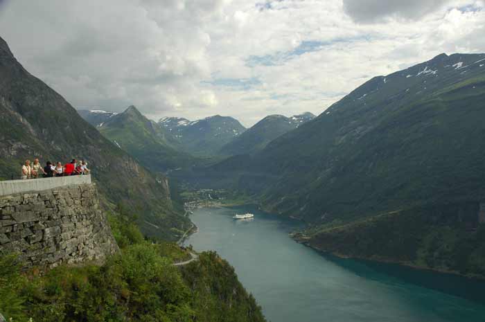
A break at the Ørnesvingen (or Eagle Bend) is a must - it is just so jam packed that it is hard to find a spot to safely stop. But we are able to squeeze in amongst a few huge tour buses. From this vantage point we have another great view of Geiranger. We can admire the Seven Sister Falls and the Pulpit. Wonderful. But at this time, it is not a quiet, peaceful spot to enjoy the beauty of nature. So, after a few quick photos, we are on our way again, making our way to the top of the curving road. The highest point on the road is at Korsmyra (altitude 624 meters) and from here we head towards Eidsdal.
Our arrival in Eidsdal is pretty well timed - we have only a 15 minute wait for the ferry to take us across the fjord to Linge. At Linge, we turn west and carry on along the edge of the fjord. At the fjord village of Sylte, we are able to see the striking zigzag stripe on Mount Syltefjell that is said to be the sea serpent Saint Olav flung against the precipice in 1028. It is amazing how much it looks like a huge snake.
After about another 30 minutes of driving, we arrive at Gudbrands Bridge, named after the gentleman who is said to have jumped over the gorge with the raging river rushing through it. As we are arriving here, the weather begins to change. There are some drops of rain and we can feel that cool, moist air rushing down the valley which is now filled with dark, storm clouds. More rain is on the way. We decide to check out the campsite at the gorge, but all the cabins are full. If there is going to be heavy rain, we have no interest in using our tent.
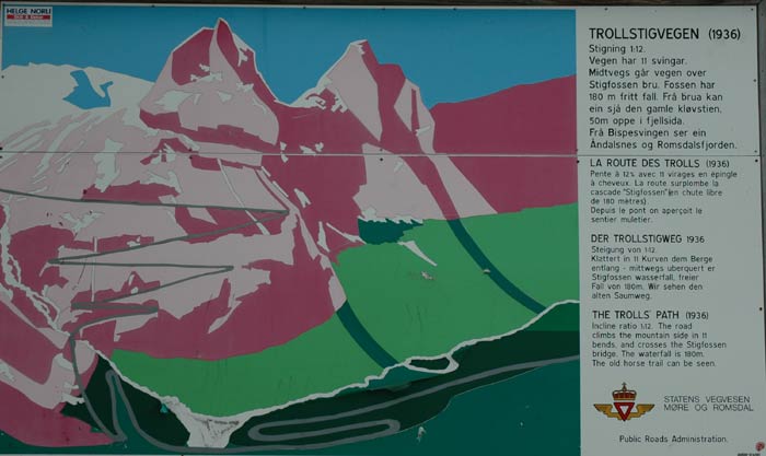
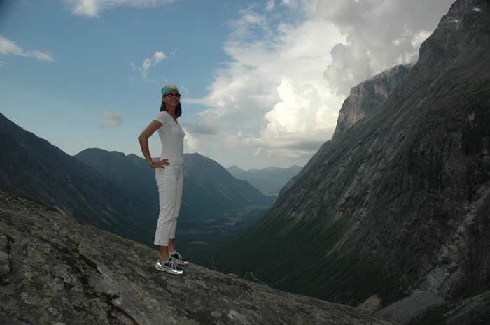
So, we have no choice but to carry on to our next destination - the famous Trollstigen. This is another 20 or so minutes away. We are lucky, as we are approaching this serpentine road, the weather clears a bit and the rain holds off. We reach the top of the Trollstigen and walk the short way to the look-out point to check out the most famous road in Norway.
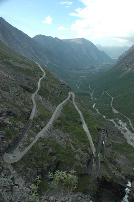
It took twenty years to complete this road and King Haakon opened it in 1936. The interesting thing is that it was not built for commercial reasons - but purely as a pleasure road. Sort of like - the mountain is there, so climb it (or in this case, build a road there). We are at the top, at an elevation of 850 meters and we will take 11 long, looping hairpin turns to descend to the valley below at 30 meters elevation. Along the way we will pass numerous waterfalls and sights.
So, after taking in the road that we will be testing, we hop back into our car, put down our roof (the rain looks like it will hold off for a while) and begin the exhilarating drive down the side of the cliff face. The road is well built. While narrow at places, there are plenty of passing bays. We pass by the Tverrdalsfoss, which drops right next to the road.
Later on we pass by the 180 meter high Stigfoss. Soon we have passed the tight turns and have entered the valley floor and we carry on slowly descending to the fjord in the distance. The valley is crowned with some really magnificent mountains. To the east, the jagged Troll peaks cut into the sky. In the west, they are countered by the Kongen, Dronningen, Bispen and Kari peaks. This is a wild and beautiful place.
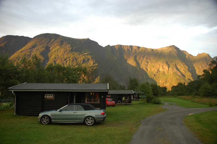
As we drive along we carry on with our search for a place to stay. The first few campsites have no free cabins. Finally, we come upon one with some free. They are not cheap, but the sudden huge down pour makes the decision for us. Enough of driving for the day. We check in and then struggle in the heavy rain to unload and settle into our cabin. We sort out our stuff and begin preparing dinner. It is a very nice cabin, well worth the price if you are a group of four or a family.
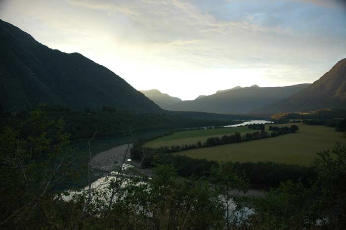
The rain soon stops and the sky begins to clear. We are able to go outside and enjoy the changing colors on the mountain peaks as the sun begins it's slow descent to the horizon. The rest of the evening is spent washing up, working on some photos and relaxing. But what a day it has been. We have seen such beautiful scenery and driven on fantastic roads.