Today is a big day - we are heading up to the base of Angel Falls by dugout canoe up rivers with extremely low water levels. We have breakfast at 7 AM and are ready to head off just before 8 AM. We cross the lagoon by boat and alight at the base of the hydro plant at the other end of the lagoon. We walk up and through the hydro electric plant to the edge of the river at the top of the falls that pour into this side of the lagoon.
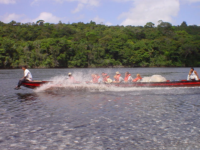
After a short walk along the river, we load into two long boats that will take us up the rivers to Angel Falls. We split up so that we are about eight or nine people in each boat. At the back is the driver, followed by all our gear that is loaded into the center of the boat and covered by plastic sheets. We are at the front third of the boat, sitting on wooden planks that became very uncomfortable over the duration of the trip. At the very front of the boat was another drew member who would play a very important role as we headed up river. Finally, each boat had a guide, who would move around the boat as required.
Just before 10 AM we were ready to push off and head up river. This was the easy part of the trip - up the river that has enough water for the boat to cruise at relatively high speeds against the strong current. There was one stretch where we had to get out of the boat and walk for about a half hour around the Mayupa Rapids as the boats were taken up the rapids by the two man boat crews. An indication of how difficult it was was provided by the fact that we walked the distance fasted than they could cover it in a motorised boat.
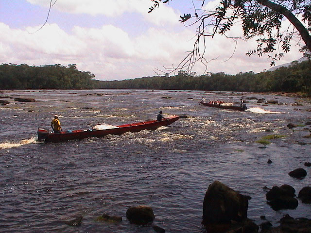
After a while we turned right, leaving the Rio Carrao and entering the Rio Churum, a tributary that winded its way down one of Auyan Tepui's canyons. Auyan Tepui is one of the many table mountains in the area and this river was much smaller than the Rio Carrao and we soon experienced some difficulties with the water level and the rapids. But it was relatively painless until we stopped for lunch on a small island composed of many rocks in the middle of the river. We got out at the bottom of the island and watched as they tried to bring the boats up around the side of the island through the rapids. As they were having some difficulties, some of us jumped in give them a hand. This gave us a taste of what it would be like for the rest of the afternoon. The strong current threatened to drag us away down river as we tried to gain a footing on the slippery rocks that lined the river bottom as we pushed the boats forward over the rocks.
Once the boats were through these particular set of rapids and tied up to the island, we sat down and enjoyed a light lunch.
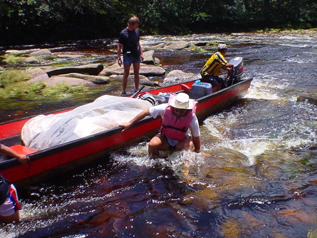
Now came the challenging part, as we headed up the rest of the way to the base of Angel Falls. It was back-braking work just trying to make some progress up the river. As we approached each rapid (which seemed to come more and more frequently), the driver would try to position us to race at the rapid at as fast a speed as possible and then pull the propeller out of the water at the last minute to avoid hitting the rocks. If the water was deep enough, we might make it to the top of the rapid if we had enough momentum. If we did not have enough momentum or we the bottom of the boat hit the rocks, we would have to jump out of the boat and try to push it up-current over the rocks and through the rapid.
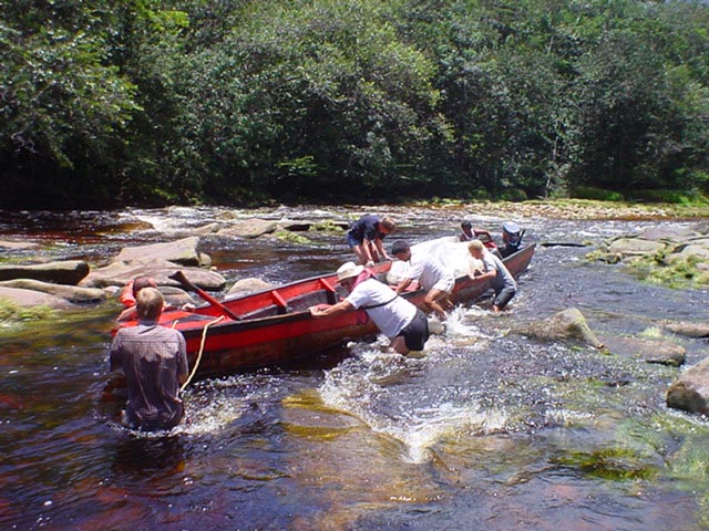
The guide coordinated this effort - it was critical to have good coordination amongst us all otherwise it would turn into a mess. He would give the command to get out and all the men (at first it was only the men that were supposed to jump out and push) would jump over the side of the boat into the river, try to get a footing and then start pushing. we would often have to coordinate our pushing to get maximum thrust. Then, when the boat was free and the driver could stick the propeller in the water, he would give the command to get back in the boat. It was critical that we would all jump in at the same time, otherwise the driver could not gun the engine and we would end up drifting back.
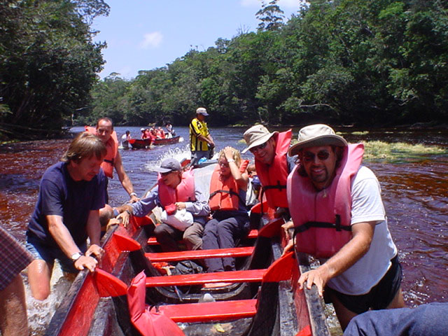
When we were in the water, we would be holding onto the boat and trying to push as he walked over the boulders under water that we could not see. Many were covered with moss and were slippery. If you lost your footing, your feet would be washed away and if you were not holding on or let go, you would be dragged away down the river. Other hazards varied from the water depth changing suddenly to being crushed against the side of the river. You would be pushing the boat along, when all of a sudden as you stepped forward you found no bottom and you would be struggling to hold onto the boat. Sometimes the navigable part of the river was very narrow and as we pushed the boat, it may swing to the side with the force of the current and threaten to crush you against the trees and rocks at the side of the river. You had to jump in quickly or "walk" your way, sideways, along the obstacle and hope that you do not slip. The other big hazard was the boat getting forced sideways by the strong current - if you were upriver, you were struggling to hold the boat. If you were downriver, you were even more desperately trying to push the boat back straight before it rode over you, crushing you between the wooden bottom of the boat and the rocky bottom of the river.
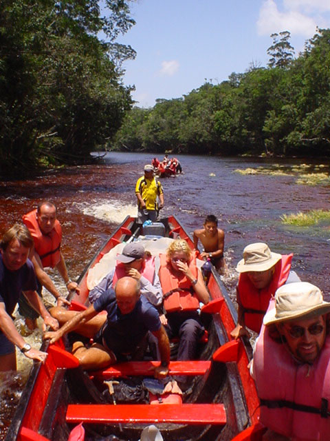
Then we had to get back into the boat. Not as easy as it may sound. The boat was a bit crowded and if you did not want to hit someone else in the face, you had to be careful hopping back in as the water got deeper and the driver was gunning the engine to keep the boat moving against the current. We usually brought a bucketful of water back in with us each time, so the bottom of the boat was soon swimming with water and whatever gear was laying there. Often you would give others in the boat a face full of cold water. Maybe that is why most of the women also started getting out and helping to push - they were getting all wet anyway. This whole exercise was sometimes done only once on a rapid, but there were times when we would repeat this "out, push and in" sequence 10 to 20 times on one rapid. It became tough on our feet - even wearing sandals we would feel the impact of the rocks. Lars' sandals acted like big scoops, with the toe of the sandal being caught by the current - he thought the sandal would break, but it held. We had to make a couple of stops along the way for the driver to take the propeller off the engine and pound it back into shape - it had been deformed from hitting the rocks. They had a good and a "used" propeller which they interchanged depending on the state of the river.
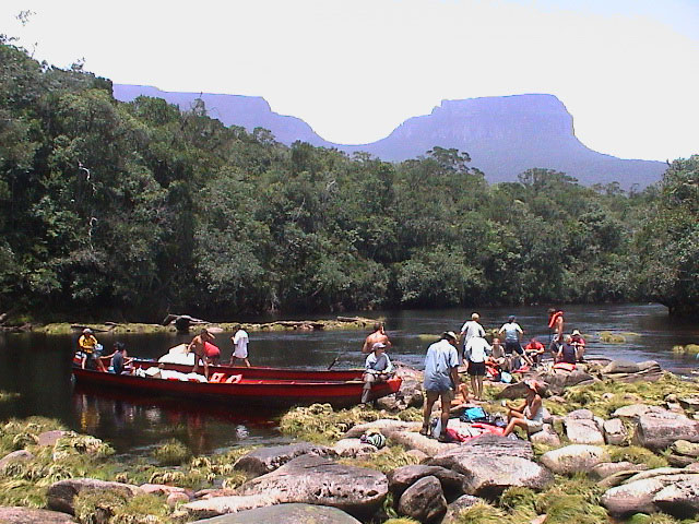
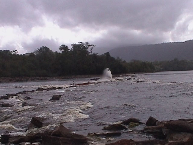
As we worked our way up the Rio Churun, it looked like we were passing through many canyons formed by a number of huge table mountains. In reality, we always had the daunting walls of the table mountain Auyuan Tepui around us as we meandered up the river. This area was the remote wild landscape that Sir Arthur Conan Doyle heard about and was the basis of his book, the Lost World. It would not be hard to imagine dinosaurs appearing from the jungle as we passed by. We finally entered Devil's Throat, the canyon leading up to Angel Falls.
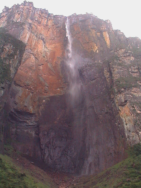
We walked the last bit - we were getting in and out of the boat every two to three meters and arrived at the camp at 4 PM. But we had no time to hang about. We had to get up to the falls and back down again before it got dark. It took us much longer than expected to get this far. We changed into our walking boots and headed up. We are so fortunate - it is a clear sky and we will be able to see the whole water fall, including the summit, in all its glory. After about half an hour we arrive at the lookout. After a short view we head onto the actual base of the falls. The view from there is magnificent. We were able to see the water fall, in what seemed like slow motion, from the top of the summit all the way down the rusty-red rock face to the bottom of the falls, 807 meters later. Halfway down the falls the water falling water spreads into a mist that slowly seems to swirl on down. It was impressive even with the water level so low.
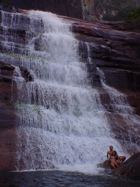
One of the guides had brought a bottle of whiskey with him, and we took a congratulatory swig at the small falls at the base called the cascades. We then stripped down to our swimmers and jumped into the chilly water for a refreshing swim. We fought the strong current near the base of the falls and climbed onto a bunch of rocks, leaning into the falls for a pounding massage. Then it was time to head back down, but not before we had one more swig, or two, of the whiskey.
We head back down to the river, hop into the boats for a ride across the river and a short walk up the slope to our camp on Isla Raton. It is a simple camp - columns with a roof and open sides. There is a small kitchen and a long tale to sit at. Hammocks eventually fill up the rest of the shelter. It is a quiet evening - dinner, some drinks and then we are ready to head off to bed. But first we head down to the river to watch the falls in the light of the nearly full moon. It is a spectacular sight, seeing the shimmering white mist against the dark cliff face.
Then off to a relaxing nights sleep in our hammocks - we were so exhausted that we just fell right to sleep. And we sleep deeply and well, except that it does get a bit cold. But they had supplied us with blankets, so we were able to keep warm.